Morphodynamics of the Karnali River and erosion of vegetated floodplains (WP4)
The research objective of WP4 is threefold. First, to understand the hydro-morphodynamics of the Karnali River system within its alluvial fan, and second to assess the reasons behind the dominant channel switching from the Geruwa to the Kauriala branch of the Karnali River system. Furthermore, the quantification of the hydrodynamics of the Karnali River system in its alluvial fan under the influence of anthropogenic effects and climate change is of importance.
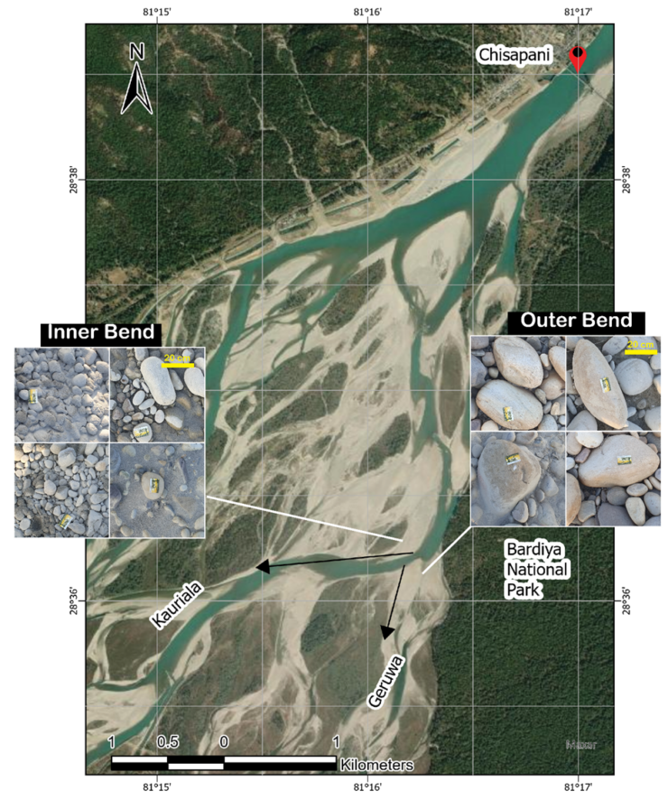
Figure 1: The background image represents the bifurcation region during a low-flow period. The photographs of the bed surface sediment were taken during the fieldwork of 2023. The bed surface in the inner bend is finer than the outer bend. The outer bend, which is also the entrance to the Geruwa shows significant deposition of coarse sediment consisting of boulders of about 50 cm diameter.
To get grip on the hydrodynamics we analysed the archival discharge time series at Chisapani from 1962 to 2019, sourced from the Department of Hydrology and Meteorology (DHM), Nepal. The discharge of the Karnali River at Chisapani varies significantly, ranging from 173 m³/s during the dry season to 17,900 m³/s at the peak of the monsoon. Furthermore, by using satellite imagery, we estimated the water distribution between the Kauriala and Geruwa branches of the Karnali system from 1972 to 2021. The results show a significant reduction in water surface area within the Geruwa branch since 2009. The braiding index (a metric used to characterized multi-threaded river systems, calculated by dividing the sum of lengths of all active channels, including secondary channels, by the length of the main channel in the river reach) of both branches decreased between 2001 and 2015 compared to the 1990-2000 period. Furthermore, the Geruwa branch shows more braiding than the Kauriala, which means Geruwa is less stable.
In 2022 and 2023, we conducted two successful field campaigns. There we collected river cross-section data, sediment samples, and photographs from various locations along both branches. We also analysed the sediment-size distribution in both branches. Additionally, real-time water level sensors were installed in the Kauriala and Geruwa branches to monitor the water discharge distribution between them. Based on these field observations, we found that large sediment particles deposit right downstream of the Karnali bifurcation at the entrance of the Geruwa branch, obstructing flow into the Geruwa branch. It seems to be reasonable that bend sorting effects and the double peak flow event in 2009 have triggered the deposition of coarse sediment at this location. Subsequent monsoon floods seem to have reinforced this effect, leading to the gradual closure of the Geruwa branch.
Based on the field observation and hydrologic data, we hypothesize that an intensive monsoon season has triggered ongoing gradual closure of the Geruwa bifurcate by transporting boulders into it, which deposited due to insufficient mobility.
A research article submitted for review focuses on describing the dominant channel switching of the Karnali in its fluvial fan and to assess its trigger. It includes analysis of hydrological data, fan topography, and channel properties. The results suggest that the intense monsoon with double peak flow in 2009 triggered the recent channel switch of the Karnali from Geruwa to Kauriala. This event seems to have initiated gradual deposition of coarse sediment at the upstream of the Geruwa, plugging its flow. The research article also compares the Karnali with a similar but more anthropogenically influenced Koshi system. The hydrological regime and morphology of the Koshi is significantly influenced by infrastructures such as dams and dikes.
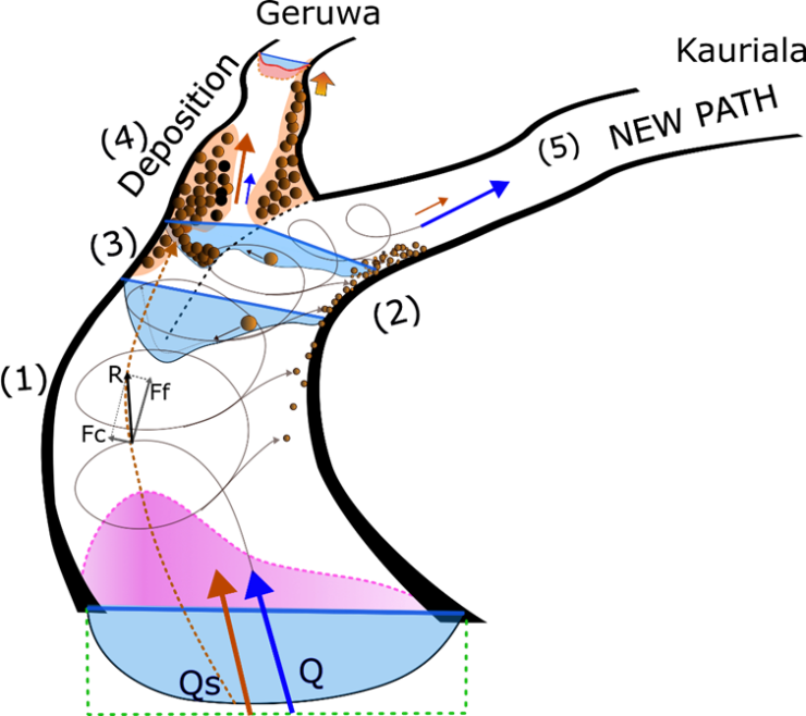
Figure 2: Conceptualization of the bend sorting effect which led to the deposition of coarse sediment at the upstream end of the Geruwa branch and hence gradual closure of the Geruwa branch.
Possible future closure of the Geruwa branch would have significant implications for water distribution and habitat conservation in Bardia NP. To mitigate ongoing changes, park officials have excavated channels to allowing for water discharge into the Geruwa branch under low-flow conditions.
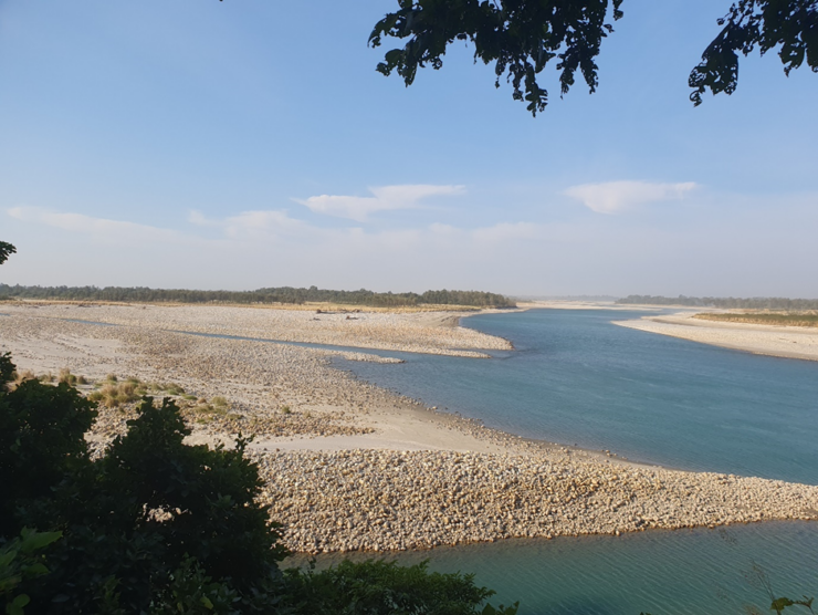
Figure 3: Image taken during low flow conditions in November 2023 showing part of the bifurcation area with the main channels of the Geruwa and Kauriala branches.
Currently we apply a hydrodynamic model to estimate water level in the Geruwa branch under different values of the water discharge and relate these results to observations of vegetation cover. These results will aid decision making processes for maintaining suitable water level in the Karnali branches for habitat sustainability. Our current research activities seek answer to the question: “How does the water discharge and associated water level influence vegetation cover in the Geruwa flood plain?”.
Research activities are:
- Analyse the relation between the hydrological regime, inundation characteristics, and vegetation cover in the Geruwa floodplain.
- Collaborate with WP 9 and with relevant PhD research at UU to develop vegetation maps of the Geruwa floodplain.
- Determine inundation extent, frequency, duration and flow depth in the Geruwa floodplain under various water discharge conditions, while including climate change and human interventions.
Outreach
Connections have been established with local authorities in the project area, facilitating sharing of data and outcomes. A seminar on the relevance of river morphology to wildlife habitats has been organised at Mid-Western University, Nepal. We utilized laboratory facilities and provided training for staff and students from the College of Engineering and Management, Nepalgunj, Nepal. Collaboration with the Karnali River Management Project to share human resources and data has been beneficial during the fieldwork.